| |
|
Golden
Canyon Interpretive Trail
Length: 1 mile, one-way.
Starting Point: Golden Canyon parking area, 2 miles south of Hwy 190 on the Badwater
Road.
Description: Easy, self-guided trail through colorful canyon. Red Cathedral
located 0.5 mile up canyon from last numbered trail marker. Trail guides are available
for 50 cents on site or at park visitor centers.
|
| |
|
Gower
Gulch Loop
Length: 4 miles round-trip.
Starting Point: Golden Canyon parking area, 2 miles south of Hwy 190 on the Badwater
Road.

Description: Colorful badlands, canyon narrows, old borax mines. Hike up Golden
Canyon to last numbered trail marker, then take path over badlands to Gower Gulch.
Hike up to Zabriskie Point or down gulch to finish loop. Two easy dryfalls must
be scrambled down in Gower Gulch. Ask for the Gower Gulch handout in Visitor Center.
Moderate hike.
|
| |
|
Desolation
Canyon
Length: 1 mile, one-way.
Starting Point: End of left fork Desolation Canyon Road, (not marked, look closely
for it) 3.7 miles south of Hwy. 190 on Badwater road.
Description: Narrow canyon through colorful badlands. From road's end, drop
into main wash heading south. Hike up canyon, keeping to right at the forks.
|
| |
|
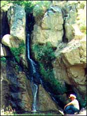
Natural
Bridge Canyon
Length: 1 mile, round-trip.
Starting Point: Natural Bridge parking area, 1.5 miles off the Badwater Road on
graded dirt road, 13.2 miles south of Hwy 190.
Description: Moderate uphill walk through narrow canyon. Large natural bridge
at 0.3 mi. Trail ends at dry waterfall.
|
| |
|
Badwater
Salt Flat
Length: 0.5 miles to edge, 5 miles across.
Starting Point: Badwater parking area, 17 miles south of Hwy 190 on the Badwater
Road.

Description: Level walk across lowest place in the Western Hemisphere, -282
feet elevation. Crust of salt crystals may be covered with temporary lake after
rain storms. Watch out for muddy areas. No Trail CAUTION: Do Not hike this area
during hot months!
|
| |
|
Harmony
Borax Works Interpretive Trail
Length: 0.25 mile, round-trip; for a longer hike, walk the 1 mile bicycle path
along Hwy 190 from Furnace Creek.
Starting Point: Harmony Borax Works parking area, 1 mile north of Furnace Creek
on Hwy 190.
Description: Easy paved trail loops around ruins of 1880's borax processing
plant. Interpretive signs along trail tell the story of what you are seeing.
|
| |
|
Salt
Creek Interpretive Trail
Length: 0.5 mile round-trip.
Starting Point: Salt Creek parking area, 1 mile off Hwy. 190, 13.5 miles north
of Furnace Creek.
Description: Easy, self guided trail on a boardwalk over small stream. Good
for viewing rare pupfish and other wildlife. Best in late winter/early spring.
Trail guides available on site or at park visitor centers for 50 cents.
|
| |
|
Sand
Dunes
Length: 2 miles, one-way.
Starting Point: Sand Dunes parking area, 2.2 miles east of Stovepipe Wells, Hwy
190.

Description: Graceful desert dunes, numerous animal tracks. Walk cross-country
to 120 ft. high dunes. Best in morning or afternoon for dramatic light. Also good
for full moon hikes. No Trail Day Hikes Outside of the Furnace Creek Area - Location
Map
|
| |
|
Mosaic
Canyon
Length: 2 miles, one-way.
Starting Point: Mosaic Canyon parking area, 2 miles from Stovepipe Wells Village
on graded dirt road.
Description: Popular, easy walk up narrow, polished marble-walled canyon. Some
slickrock scrambling necessary. "Mosaics" of fragments of rocks cemented together
can be seen in canyon walls. Bighorn sheep sighted occasionally.
|
| |
|
Titus
Canyon Narrows
Length: 1.5 miles, one-way.
Starting Point: Titus Canyon Mouth parking area, 3 miles off Scotty's Castle road
on graded dirt road.
Description: Easy access to lower Titus Canyon road. Follow gravel road up
wash 1.5 mi. through narrows or continue to Klare Springs and petroglyphs at 6.5
miles. No camping allowed.
|
| |
|
Dante's
Ridge
Length: 0.5 miles to first summit, 4 miles one-way to Mt. Perry. Starting Point:
Dantes View parking area.

Description: Follow the ridge north of Dantes View for spectacular vistas and
a cool place to escape summer heat. No Trail for last 3.5 miles.
|
| |
|
Keane
Wonder Mine Trail
Length: 1 mile, one-way.
Starting Point: Keane Wonder Mill parking area, 2 miles off Beatty Cutoff road
on graded dirt road.
Description: Very steep, narrow trail from mill ruins to mine 1500 ft. above.
Sweeping views of Death Valley. CAUTION: Do not enter any mines - they are unstable
and hazardous. Do not remove any historical artifacts.
|
| |
|
Keane
Wonder Springs
Length: 1 mile, one-way.
Starting Point: Keane Wonder Mill parking area, 2 miles off Beatty Cutoff road
on graded dirt road.
Description: Follow pipeline north along mountain base to sulfur springs and
travertine mounds. Beyond springs are remains of an old stampmill and cabin. Do
not remove any historical artifacts.
|
| |
|
Little
Hebe Crater Trail
Length: 0.5 mile, one-way.
Starting Point: Ubehebe Crater parking area, 8 miles west of Scotty's Castle.
Description: Volcanic craters and elaborate erosion. Hike along west rim of
Ubehebe Crater to Little Hebe and several older craters. Continue around Ubehebe's
rim for loop hike
|
| |
|
Darwin
Falls Trail
Length: 1 mile, one-way
Starting Point: Darwin Falls parking area, 2 miles off Hwy 190 on graded dirt
road, 1 mile west of Panamint Springs Resort.
Description: This small waterfall flows year round in a deep, rugged gorge.
Thick vegetation and muddy stream crossings can be challenging. Public water supply,
no swimming or bathing please. Adventurous Hikes: No trails. Rock scrambling...
you're on your own!
|
| |
|
Death
Valley Buttes
Length: 1.8 mile, one-way.
Starting Point: Hell's Gate parking area, 22 miles NE of Furnace Creek.
Description: Short but strenuous scramble to the two prominent hills at the
foot of the Grapevine Mountains. From Hell's Gate, walk SW 0.5 mile toward the
buttes. Scramble south up the ridge to the first of the buttes. You made it! Now
you can decide whether you want to attempt #2. It's more difficult. If so, descend
carefully down the ridge 300 ft., then climb the narrow ridge to butte #2. Extreme
care should be used when climbing the buttes. Ridges are narrow and exposed with
steep drop-offs. Windy days make this effect quite dramatic. The views are among
the best in Death Valley. No Trail
|
| |
|
Fall
Canyon
Length: 3.5 miles, one-way.
Starting Point: Titus Canyon Mouth parking area, 3 miles off Scotty's Castle road
on graded dirt road.
Description: Deep and spectacular canyon north of Titus Canyon. Walk 0.5 mile
north along base of mountains to large wash, then 2.5 mi. up canyon to a 35 ft.
dryfall. Using caution, you can climb around the falls on the south side. This
will give you access to some of the most beautiful narrows in Death Valley. You
can follow the canyon up another 4 or 5 miles. No Trail
|
| |
|
Red
Wall Canyon
Length: 3 miles, one-way.
Starting Point: Scotty's Castle Road, 3.8 miles north of Titus Canyon road exit.
Description: Colorful (red) narrow mountain canyon. From road, hike 2 miles
up alluvial fan to mouth of canyon (watch for meeting of red and black rock to
locate canyon). Rock climbing skills are needed to continue beyond a dry waterfall
1 mile up the canyon. No Trail
|
| |
|
Little
Bridge Canyon
Length: 3 miles, one-way.
Starting Point: 3 miles east of Stovepipe Wells Village, Hwy 190. Park along side
of road, (first major canyon east of Grotto Canyon).
Description: Ascend alluvial fan 2 miles south of road to canyon mouth. The
canyon is very wide at first before narrowing. A small arch appears on the right
1/2 mile into the canyon and a 20 ft high natural bridge spans the east side of
the canyon 1/2 mile further on. White quartzite canyon walls and interesting side
canyons to explore. Canyon narrows further up from bridge. No Trail Summer Hikes:
Cool places to hike when the Valley gets too hot.
|
| |
|
Wildrose
Peak Trail
Length: 4.2 miles, one-way.
Starting Point: Charcoal Kilns parking area, upper Wildrose Canyon Road.
Description: A good high peak to climb (9,064 ft.). Trail begins at north end
of kilns with an elevation gain of 2,200 ft. Spectacular views beyond 2 mile point.
Steep grade for last mile.
|
| |
|
Telescope
Peak Trail
Length: 7 miles, one-way.
Starting Point: Mahogany Flat Campground, upper Wildrose Canyon Road. Rough, steep
road after Charcoal Kilns.
Description: Strenuous trail to highest peak in the park (11,049 ft.) with
a 3,000 ft. elevation gain. Ancient bristlecone pines appear just above the 10,000
ft. level. The summit rewards you with spectacular views ranging from Badwater,
the lowest point in the Western Hemisphere to the east, to Mt. Whitney, the highest
point in the lower 48 United States to the west. Climbing this peak in the winter
requires ice axe and crampons, and is only advised for experienced climbers. Telescope
Peak is usually snow-free by June. Don't forget that the high altitude may slow
you down.
|
 |
|
|


 HIKING